


Traveling to the west of Iran is like discovering a new land with extraordinary travel potential. Each of the western provinces of Iran offers a list of the most prominent historical, natural, and cultural attractions. No matter which reason motivates you to visit there, you will experience spectacular scenes of Persia’s tangible and intangible heritage, from plains with unique biodiversity to sites with exceptional geographical features. When you add the cultural authenticity of the people in western Iran, you will experience some of the most distinctive attractions. Discover the West of Persia with FlySepehran.
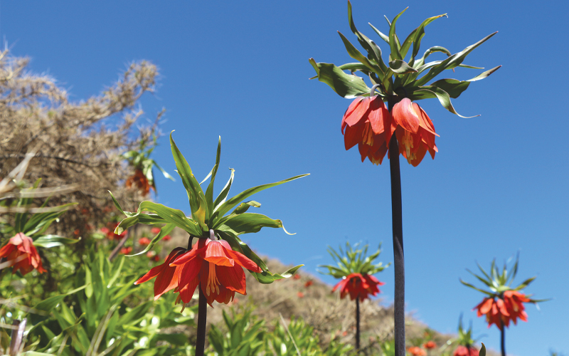
The Kuhrang Plain of Overturned Tulips (Fritillaria) is the vastest ecosystem for Fritillaria in the world that offers an awe-inspiring landscape in spring. The plain, spanning an area of 3600 hectares, is designated as a Natural Monument and is under conservation by the Department of Environmental in Iran. The Kuhrang plain is covered entirely with a unique species of Overturned Tulips (Fritillaria) in warm orange, red, and yellow colors, with a stem height of some reaching 120 centimeters.
Over 140 species of Fritillaria have ever been identified worldwide, with 14 being native to Iran, and the others growing in Europe, Western Asia, and Central Asia. The most known Fritillaria species in Iran are also famous Iranian Fritillaria, Turkish or Kurdish Fritillaria, Mary’s Tears, Tear Flower, Shy Flower, and Zagros Tulips. Their ecosystem is west of Iran, specifically on the slopes of Kuhrang and Dena mountains. Some species have also been grown in the plains of Fars, Isfahan, Lorestan, Ilam, and Kermanshah provinces. The best time to visit Overturned Tulips Plain in Kuhrang is spring, and Kuhrang is ready to host thousands of colorful tulips during this period. The site is ready to be visited in mid-April to late May. The access route to the Kuhrang Fritillaria sites is also incredibly scenic. Along the way, green hills, snow-covered mountains, and flowing springs make sightseeing landscapes. Geographically, the world’s greatest Overturned Tulips Plain is situated in Chelgerd, on the path to the Kuhrang ski resort.
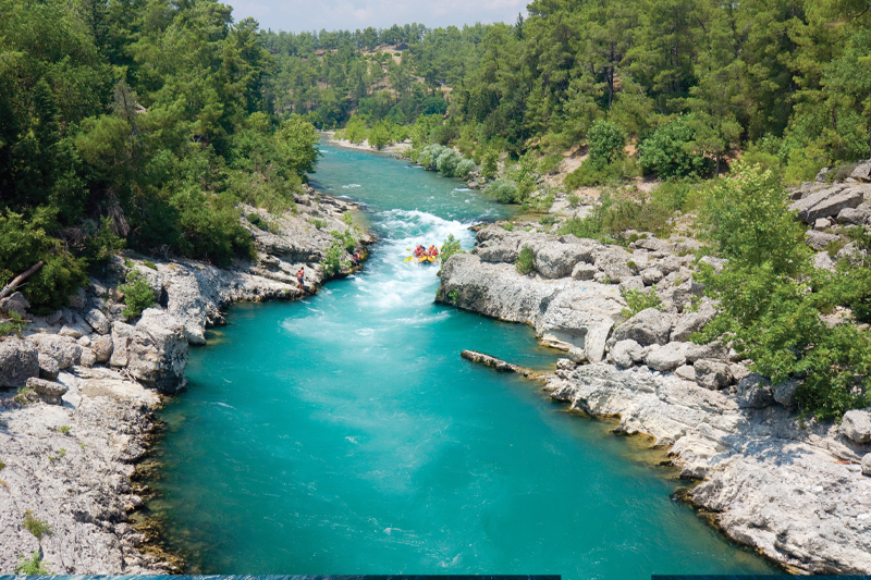
The Armand River, one of the most significant rivers of Iran, located in Lordegan City, Chaharmahal, and Bakhtiari province, is a natural attraction in western Iran. This beautiful river includes the stunning landscapes around it and is considered one of Iran’s most famous rafting sites. The unique natural features of Armand consisting of the appropriate length, width, and depth, make it an excellent choice to experience the roaring river rafting for both beginner and advanced adventurers. Armand plants, composed of species like the oak and hawthorns, provide a suitable habitat for various animal species. The river paths through beautiful, eye-catching mountainous nature, eventually joining the Bazoft River and flowing into the Karun 4 Dam. The regional climate conditions make the Armand River a perfect site for adventure activities.
If you are looking for adventurous activities, spring is the golden season to experience rafting in Armand, when the river has its most roaring waters. If you are planning, although, to experience rafting for the first time, summer is the right season for you when the water level is lower and the speed of the river flow decreases. To visit Armand, you can go from Isfahan city towards Mobarakeh, then pass through the cities of Boroujen, Boldaji, Chaghakhor, Naghan, and Durak to reach Darreh Yas village, and then go to Armand River.
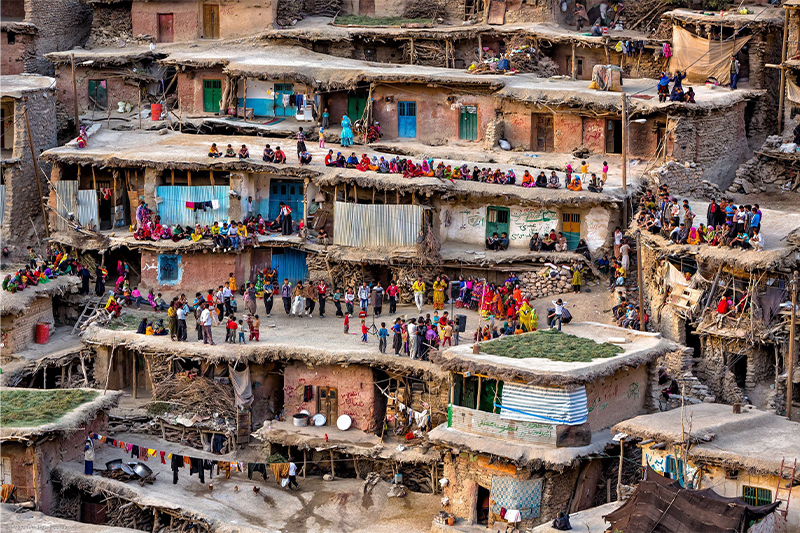
The terraced village of Sar Agha Seyed, known also as the “Masouleh in Zagros”, is one of the most scenic landscapes in western Iran. Located in the northwest of Chelgerd City, Chaharmahal, and Bakhtiari Province, it is recognized as a unique village in the list of Iran’s national heritage. Sar Agha Seyed is situated at 2500 meters above sea level on the slopes of the Haft Tanan Mountain. The majority of the village houses are built of mud bricks, have no windows, and their doors open towards the Haft Tanan Mountain, and the tomb of Imamzadeh Agha Seyed. The village’s Local dishes include Ash – e Kardah (Ash Kardeh), Ash-e Barg, and Nan-e Golak. Traditional music and dance are an integral part of wedding customs in this village. The inhabitants spend the cold months of the year isolated by snow and without contact with the outside world.
As spring arrives and the weather gradually warms up, travelers can access the village, and the local community prepares to welcome tourists. The interaction with the local community of Sar Agha Seyed is one of the cultural attractions of the village; they welcome tourists, as well as do farming. Among the historical attractions of the village, is the mausoleum of Imamzadeh Seyed, which is the reason for the village’s naming. This shrine is said to be 600 years old. As for natural attractions near the place, the Salt Spring, Chama Ice Cave, and Chelgerd Ski Resort are noteworthy. To get to Sar Agha Seyed Village, start your journey from the city of Chelgerd, then go towards Sheykh Ali Khan. Upon arriving at the Sheykh Ali Khan waterfall, continue along a dirt path, and soon you’ll find yourself in one of the most picturesque villages in western Iran.
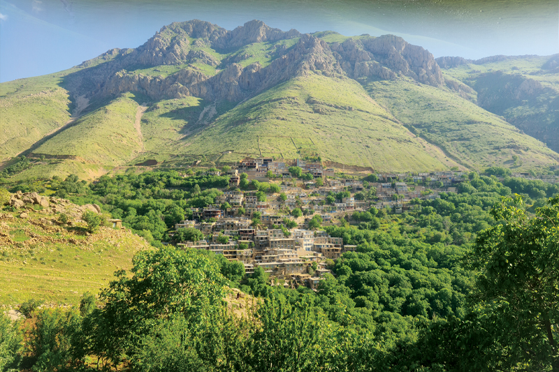
The cultural landscape of Uramanat (known also as Avroman or Hawraman), listed in UNESCO’s World Heritage Sites, is one of the most attractive destinations in western Iran. This mountainous region, nestled in the heart of the Zagros Mountains in Kurdistan and Kermanshah provinces, encompasses two areas: the Central-Eastern Valley (Zhaverud and Takht, in Kurdistan Province), and the Western Valley (Lahun, in Kermanshah Province). The Hawrami people have inhabited the region since about 3000 BCE. The mode of human habitation in these two valleys has been adapted over millennia to the rough mountainous environment. In addition to the natural landscapes, the lifestyle of the Hawrami people also attracts tourists.
Tiered steep-slope planning and architecture, gardening on dry-stone terraces, livestock breeding, and seasonal vertical migration are among the distinctive features of the local culture and life of the semi-nomadic Hawrami people who dwell in lowlands and highlands during different seasons. Moreover, the traditional clothing, Hawrami dialect, and the ancestral music playing known as “Daf Navazi”, all shape the indigenous culture of Hawrami people that attracts cultural tourists from around the world.
Besides making traditional musical instruments, which is an ancient art craft in Uramanat, this region is also renowned for making handicrafts such as Kurdish clothing and jewelry. Additionally, the region’s local music stands out as one of the most vibrant forms of Iranian folk music, contributing significantly to the area’s native cultural heritage conservation. The best time to visit Uramanat is in April and May. However, the cultural festival of Pir Shalyar, held in February, is one of the main reasons for visiting Uramanat in winter.
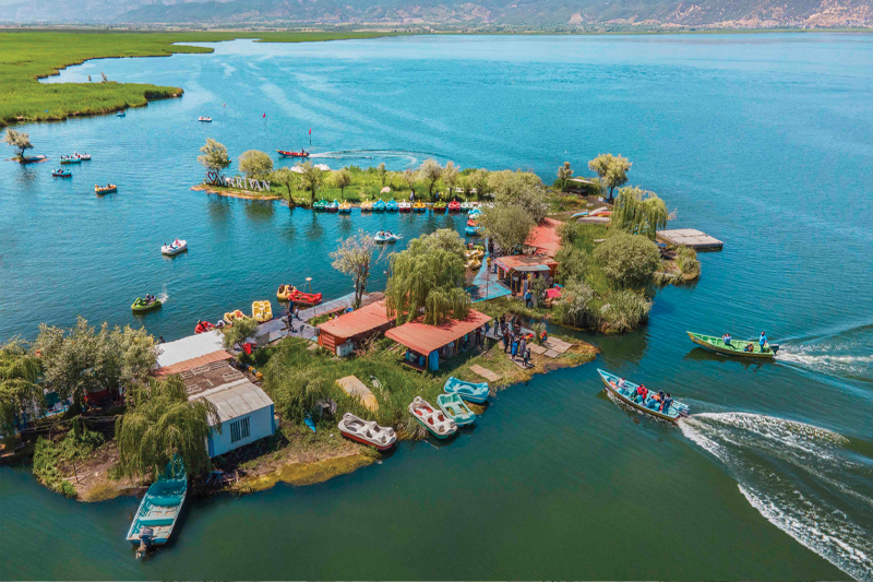
Zrebar Lake also known as Zeribar or Zrewar, is a lake in the Zagros Mountains, within Kurdistan Province. This lake is one of the precious natural treasures of Kurdistan province and the city of Marivan, recognized as a prominent tourist destination in Western Iran. The freshwater lake of Zrebar, with approximately 5 kilometers long and 6 meters deep, has been listed as a natural heritage since February 2011. Zrebar is a habitat for a diverse species of local and migratory birds, and the variety of bird species makes it one of the best birdwatching sites in Western Iran.
Nature enthusiasts and wildlife observers thanks to bird-watching equipment, and having a little patience can enjoy watching unique scenes of birds such as Common Pochard, Mallard birds, Bitterns, various types of Coots, Sternidae, Gulls, Grey Heron, Eurasian Teal, Storks, and the birds of prey such as the Western Marsh Harrier and Kestrel. Additionally, the Zrebar is a habitat for various local fish species including Capoeta, Medusafish, Gambusia, and Anguilloide. For nature lovers and wildlife photographers, a trip to Zrebar Lake offers an unparalleled opportunity to capture the pristine beauty of this ecosystem. The views of the sunrise and sunset add to the lake’s allure. Alongside its natural beauties, Zrebar Lake also offers a variety of recreational activities such as boating, fishing, and paragliding, ensuring enjoyable moments for visitors. The best time to visit this lake is during spring and summer when you can enjoy the scenic views and cool weather.
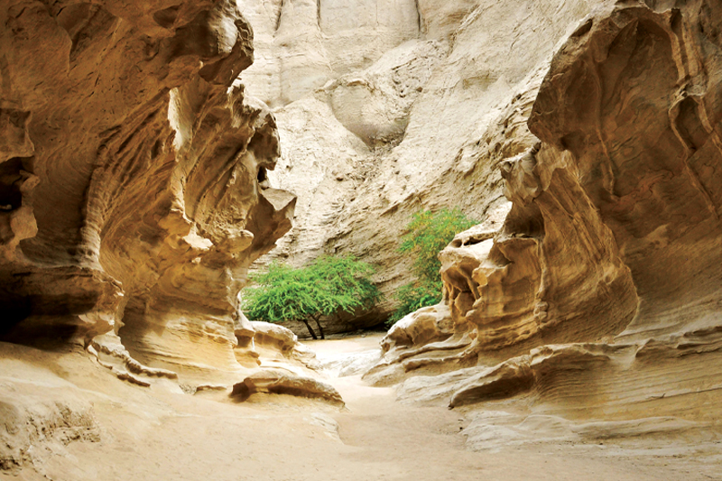
Strait of Razianeh is one of the most beautiful and pristine natural landscapes in Western Iran, nestled in the lush mountains of Ilam, presenting an astonishing view. This deep natural valley is considered one of the most spectacular geo-sites in the Kabirkouh mountain range. This site is attractive for adventure-seekers and nature enthusiasts thanks to an ancient pathway leading to the villages of “Ganjeh”, “Pakale Garab”, and “Chenar Bashi”. The Strait of Razianeh is among the narrowest canyons in Iran; its width in some parts is just 1 meter, it spans a length of 2 kilometers, and the height of walls sometimes reaches 30 meters.
Water flows in the canyon’s crevice, from a seasonal spring. Although, the unique structure of the canyon makes it a suitable habitat for various species of wildlife, birds, reptiles, and plants. This canyon is one of the best sites for mountain climbing, ecotourism, and wildlife photography. Its easy access to the city of Ilam makes it one of the best destinations for spending a full day in nature. While walking through the canyon needs technical instruments, physical and mental preparedness, and basic knowledge of canyoneering, climbing, and hiking, the area around is well-suited for tourists at any capability level. Visiting the Strait of Razianeh offers a unique opportunity to experience the pristine wilderness of Western Iran; an experience that you cannot find in any guidebook or travel magazine.
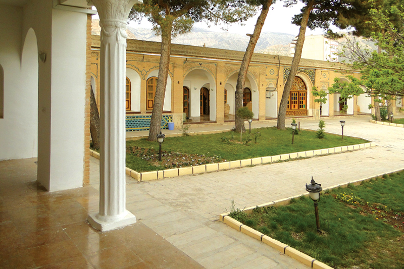
The Brick Castle of the Vali, a historical monument in Ilam City, is a valuable example of art and architecture dating back to the Qajar era. This mansion, built in 1908 by Gholam Reza Khan Vali at the top of a hill named Choghamirg, with an area of 4687 m2, and a foundation of approximately 1464 m2, is considered a precious historical heritage in western Iran. The castle has three gates located on its eastern, western, and southern sides. The south door was the main door used for the most important persons, and the two others were used for the residents.
The castle has five spacious rooms, as well as twenty smaller rooms, designed predominantly interconnected. Four porches and two small terraces on the north side, along with a basin in the center decorated with marble and colored tiles, have given the interior yard of the castle a distinctive charm. The Harem Sera (part of the castle specialized for women), and the Mirror Room are located in the basement. The ceilings are embellished with beautiful mirror works, and some of them remain in the rooms on the western side. The lattice windows designed with colorful glasses, turquoise-colored brick railings, traditional wooden lattice windows (Orsi), circular columns, and arches are among the decorations of this historic castle. The castle’s water was supplied from a spring through a traditional water distribution system, and leading to the central courtyard. In 2006, this castle was changed to an ethnographic museum to show the architectural art of the Qajar era, the lifestyle of that period, as well as statues of political and cultural figures of the time.
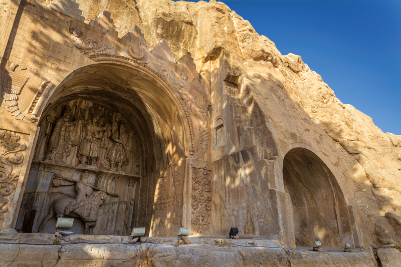
Taq-e Bostan, locally known as “Taq Bagh,” is one of the most magnificent rock reliefs from the third century AD. This stone arch comprises a collection of ancient petroglyphs and inscriptions dating back to the Sassanid Empire, engraved into the heart of the mountain. The historical site of Taq-e Bostan is near a natural old spring located in the northeast of Kermanshah city. On this site, there are ancient engraves in two arches, one small and the other large, made of raw gray stone.
The large arch, having a rectangular space, is considered the main relief of this collection. The petroglyphs narrate scenes from the coronation ceremony of Khosrow Parviz, Ardeshir II, Shahpur II, and III. Scenes of horseback hunting, and musicians playing musical instruments, along with several Pahlavi script inscriptions beside the mountain and the scenic spring, have created a pleasant, picturesque tourist site. In the royal hunting ground relief, the principles of painting have been so masterfully adhered to that it appears as if they were carved from a painting. The scene depicting wild boar hunting is among the masterpieces of this relief, resembling a wall painting.
The details used in the engravings of the kings’ garments, as well as musicians, and horsemen’s clothes, are so real and artistic that confirm this masterpiece. Being close to the ancient Silk Road, was the reason for engraving this masterpiece, so that the passersby over thousands of years could witness the splendor of ancient Iran.
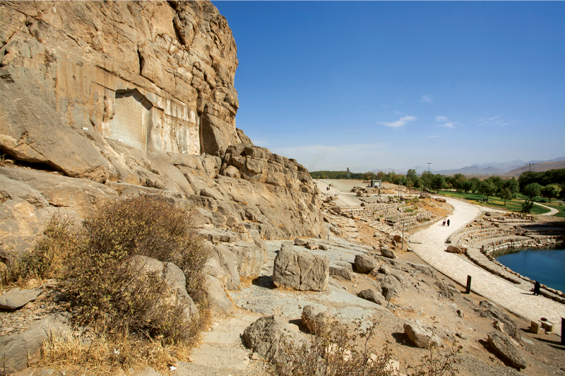
The historical site of Bisotun, alongside one of the main communication routes between Iran and Mesopotamia, and on the walls of the sacred Bisotun, narrates the sequence of ancient Iran’s historical and cultural heritage. Currently, 28 historical artifacts from the Bisotun Mountain are among the National Heritage of Iran, and the presence of Bisotun’s inscriptions in the UNESCO World Heritage list is a confirmation of the historical importance of this site. The combination of the mountain, spring, cultural masterpieces, and ancient inscriptions on this site, has changed it into a unique tourist attraction in western Iran.
The inscription of Dariush the Great, the world’s largest cuneiform inscription, along with reliefs, depicts the glory of ancient Iran. This stone tablet, one of the most famous historical documents in the world, and the most important historical text dating back to the Achaemenid Empire, covers about 120 m2 and is written in three languages: Ancient Persian, Babylonian, and Elamite. Observing this inscription and its reliefs, which describe the victory of Dariush the Great over the false king Gaumata, and the capture of rebels, is like hearing the voice of great ancient Iran’s history shouting from among the stones and cliffs. The most fascinating part of visiting Bisotun is the spring gushing from the heart of the mountain, alongside the inscriptions and ancient reliefs, creating a pleasant and scenic recreational area. Visiting Bisotun, thanks to this spring, offers an opportunity to experience tranquil moments beside one of the oldest stone tablets in the world.